
When late last year my friend Dr. Allan Tulchin asked for my help preparing two maps for a book on the history of the Protestant Church in medieval France, I was so happy to oblige. I love maps and I love historical research. Preparing these maps would exercise my mapping skills using GIS software and provide some professionally oriented extracurricular work during my intense program in Rabbinic midrash at Yeshivat Hadar. Six months later and Allan showed me proofs of his book, That Men Would Praise the Lord: The Triumph of Protestantism in Nîmes, 1530-1570 now available from Oxford University Press. I found the maps I prepared in his concluding chapter.
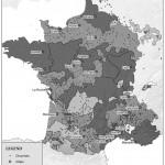
The two maps indicate the distribution of Protestant churches in Medieval France. Allan provided tables in MS Access indicating the location of churches and population groups, and hand drawings indicating the historical boundaries of French territorial expansion. Geolocating the data from the tables was not difficult thanks to ArcGIS. There were a few challenges in making the maps: 1) being limited to black and white illustration, 2) determining suitable icons, and 3) converting images of French territorial boundaries to centerline shapefiles in ArcGIS.
The main challenge was converting Allan’s scanned images of French territorial boundaries to an ArcGIS layer. That way all the layers could be manipulated and rendered within one application. For example, note the shading of the different territories–it would have been much more convenient to have each territory identified in a shapefile and then coded them according to metadata. Unfortunately, converting the raster image to a drawing proved difficult without AutoCAD (which was prohibitively expensive). Ultimately, the process required preparing the maps in ArcGIS without the boundary layer, then exporting graphics from ArcGIS into Photoshop, where the territory layer could be shaded. Given these limitations, I think the results look very nice in black and white.
If you are preparing a historical map for your research, I’d love to help and my prices are quite reasonable. Contact me.


“Beyond the Omphalos: Three Maps of Late Medieval France” is shared by Aharon N. Varady with a Creative Commons Attribution-ShareAlike 4.0 International copyleft license.
Wow. Good for you!